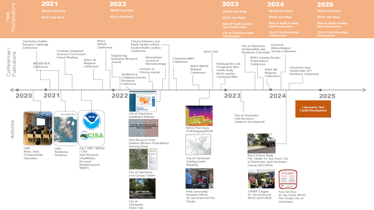
Stepping Up to the Challenge
Since beginning in 2020 with targeted research at the Charleston Medical District, research and exploration on the Lowcountry’s exposures to extreme heat continues to grow as does research collaboration and pilot project development. Figure 15 illustrates the timeline of the CHHRP work to date. Brief summaries of these activities and supporting materials follow.
Heat Proclamations
The State of South Carolina, Charleston County, the City of Charleston, and the Medical University of South Carolina now issue heat proclamations and host heat awareness events to increase attention to this growing hazard.
To learn more: Charleston Makes City Heat Proclamation
Charleston Medical District Surface Heat Mapping
In 2020, the Charleston Medical District Advisory Group and Climate Adaptation Partners (CAP) conducted surface temperature sampling at the Charleston Medical District (CMD). The intention was to capture surface temperatures at public gathering areas, recognizing the challenge of COVID-19 and the need for outdoor respite. Over the course of a typical summer day, CAP captured FLIR imagery at gathering spaces and walking routes across the properties of the three CMD institutions. CAP noted differences in material types and location (whether sun or shade). Coupled with satellite data, CAP then summarized these through visuals, ultimately illustrating extreme temperatures in recently completed environments and noting a 40-degree temperature differential across material choices within the CMD. Results were then presented to the Charleston Medical District Advisory Group, recognizing that CMD patients’ exposure to such heat and innate sensitivities to heat in sensitive populations, warrant further attention.
To learn more:
- Green Infrastructure, Climate, and Cities Seminar 2021-10-06
- Robert Lunz Group Understanding Heat Risk in Charleston April 72022_Zoom Meeting recording
Charleston Heatwatch Campaign
In 2021, Charleston conducted its first HeatWatch community science campaign. With nearly 30 volunteers on a typical summer day, the team drove 10 routes crosscutting the City of Charleston and portions of North Charleston and capturing over 57,000 heat index measurements in the morning, afternoon, and evening. Results showed a higher heat impact from morning to evening in areas of denser development, particularly in commercial and industrial areas, with the Peninsula being far warmer than outlying areas. Conserved forests were cooler and had greater cooling impact than water bodies, reducing the concentration of heat near dense single-family neighborhoods. Comparatively, neighborhoods with less tree canopy concentrated heat. There were no effects of swampy areas as compared to regular forest. Across the study area, there was a nearly 12-degree temperature differential.
In parallel, 3 teams used FLIR cameras to capture representative thermal imagery illustrating surface temperature changes over the day. These images helped to describe the increases in urban heat in paved public spaces such as bikeways and basketball courts, in turn raising heat risk awareness. Results were then presented to the City of Charleston Resilience and Wellness Committee.
To learn more:
- The City of Charleston provides summaries of these activities on their HeatWatch webpage and through their interactive maps. Results and source data from HeatWatch are available on the Open Science Forum.
Wet Bulb Globe Temperature Campaign
Also in 2021, and in parallel with the HeatWatch Campaign, the Southeast Regional Climate Center led by Chip Konrad and then doctoral student, Jordan Clark, worked with a cohort of student volunteers to capture WBGT in the Charleston Medical District.
Since WBGT uses several variables to calculate heat, it can vary greatly in short distances, such as between a tennis court and adjacent grass field and sun versus shade. This was demonstrated in Charleston through the Charleston Medical District in which 8 Kestrel Heat Trackers were set up in areas frequented by respite seekers, outdoor workers, and transit riders. Some of the highest WBGT readings were found at the patient drop off area at the Veterans Administration hospital due to the impervious surfaces. Some areas in the wind shadow of the medical buildings also recorded high WBGT.
To learn more:
- Clark, Konrad & Grundstein 2024
- Clark and Konrad 2024a
- CMD WBGT Mapping 2021
- Konrad WBGT Presentation 2022
Personal Heat Monitoring Campaign
A third initiative, in parallel with the 2021 HeatWatch Campaign and the WBGT Study, focused on personal heat monitoring of outdoor workers at MUSC and The Citadel. Many studies report on urban heat islands and variations in temperature and humidity around cities. Often, however, the weather forecast and guidance for heat health safety is based on information for a weather station in a fixed location (e.g. near an airport). To better understand individuals’ heat exposure and physiological heat strain, we need to better measure how people experience heat variability (indoors and outdoors) and the physiological impacts.
To address this gap, the personal heat monitoring study focused on personal heat exposure and estimating heat strain of grounds and public safety workers movements throughout their workplaces (indoors and outdoors) in Charleston, SC. Twenty-five workers were equipped with a GPS enabled watch tracking their heart rates (e.g. fitness watch) and a hydrochron ibutton sensor (size of a dime, worn pinned to the outside of a shirt) to measure temperature and humidity at 5-minute intervals to create Individual Heat Index Exposure (IHIE) measures. A higher IHIE metric was positively associated with length of time to heat strain. Comparison with exposure metrics that reflect the intensity, duration, or frequency characteristics of IHIE did not show a significant association with time to heat strain. The IHIE measures were statistically significant similar to the Heat Index calculated at the weather station, although measurements of temperature and relative humidity individually showed more pronounced differences. The real-time monitoring of heat exposure and physiologic response offers useful insights into temperature and health trends as well as outdoor workers’ coping strategies for high heat days.
To learn more: Individually experienced heat index in a coastal Southeastern U.S. city among an occupationally exposed population. Margaret M. Sugg, Jennifer D. Runkle, Kirstin Dow, Janice Barnes, Scott Stevens, John Pearce, Brian Bossak and Scott Curtis.
Charleston Heat Health Research Program (CHHRP)
In 2022, the Citadel and S.C. Sea Grant Consortium led teams of scientists and community scientists to evaluate heat impacts in urban environments around the City of Charleston. The team measured the heat (using WBGT and thermal imagery) at different locations and on different materials in a public housing community. Findings showed that some of the hottest areas in the community were at the playground and that the color of the asphalt roof affected its temperature. To expand this work, from summer 2023, a subset of the team is measuring the heat coming off roads and sidewalks. The team found that heat stress was more pronounced and dangerous at 1.6 ft (0.5 m) as compared to 5 ft (1.5 m). This has implications for children and pets to assess if a treatment used to extend the life of the road had noticeable secondary benefits as measured in lab. Preliminary results indicate the treatment does not have a notable effect to date, but more research will be conducted in summer 2024.
NOAA Heat Tabletop Exercise
In 2022, NOAA facilitated a two-day tabletop exercise that presented multiple climate change and heat-related scenarios for participants’ responses. Tabletop attendees included staff from the City of Charleston, Charleston County, federal agencies, state agencies and academic institutions. Scenarios included short-term and long-term planning to better understand the suite of partners involved in reducing heat impacts, communication needs and considerations, and gaps in understanding heat implications. Due to the exercise and conversations spurred, the region has made headway on reducing heat impacts through various ways, such as local heat awareness week designation and collaborations and knowledge sharing with other cities. Areas identified for improvement included better data on heat and health, economic impacts, increased messaging for heat health concerns and updated practices or policies to reduce heat risk.
To learn more: Final Charleston Heat AAR.pdf
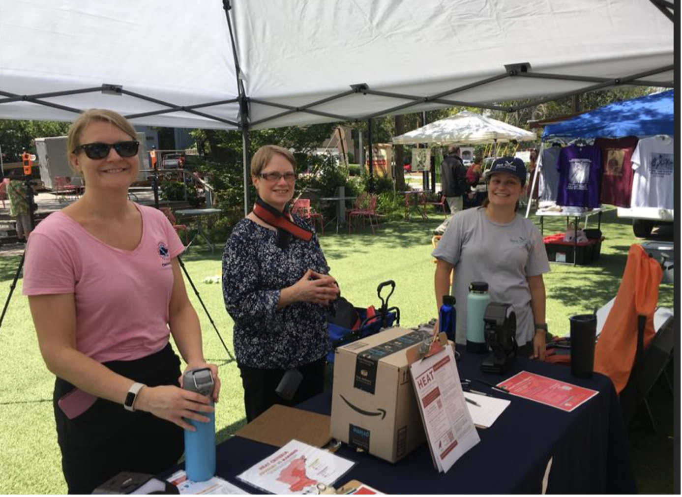
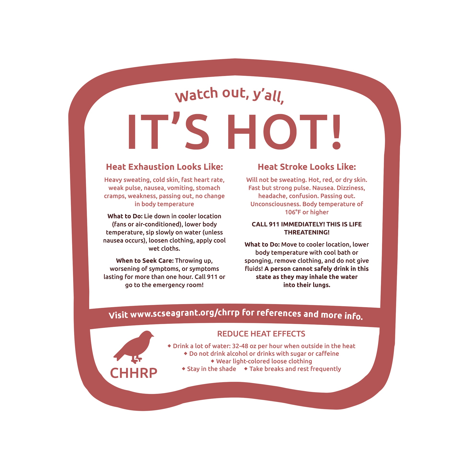
CHHRP Pop Up Events
In 2023 and 2024, the Citadel and SC Sea Grant, along with MUSC, hosted a range of community-pop-up events in Charleston and Mt. Pleasant (Figure 16). The team shared information on how to identify heat illness and cooling centers within the City of Charleston. The team also distributed fans with reminders of these resources. These are available to download here and here.
Publicly Available Data and Resources
The City of Charleston provides resources to help community members better understand heat and the options to address the problem.
Street Tree Canopy Storymap
The Street Tree Canopy Storymap is an interactive exploration of street tree canopy coverage in Charleston’s subdivisions and its connection to heat and equity, presented through a series of questions and answers. Its primary component is a map of 500+ subdivisions, each shaded pale-yellow to dark green with a corresponding label denoting their respective street tree canopy coverage. Street tree canopy coverage is defined as the percentage of tree canopy covering the area 50 ft on either side of the street centerline (as opposed to total subdivision area coverage). Clicking on a subdivision displays its name, length of street miles, percent street and total canopy as well as percent paved/impervious, and average year built. As the user scrolls down, subdivisions with high canopy coverage are filtered out, followed by new subdivisions where trees are expected to grow and provide more shade in the coming years. The analysis then incorporates temperature data collected during the 2021 HeatWatch campaign, plotting morning, afternoon, and evening temperature against tree canopy coverage. Next, the Storymap addresses equity, where low-canopy subdivisions are mapped alongside demographic data like socioeconomic status. Clicking on subdivisions in the demographic maps displays population, race, income, and vehicle ownership information. Finally, a comprehensive mapping application with all described layers, plus additional related layers, enables users to explore the data independently. The Storymap concludes with a call to action, encouraging citizens to plant trees on their properties.
To learn more: https://storymaps.arcgis.com/stories/593cdef7583444949e70845a6bf1f8fd and https://www.arcgis.com/apps/webappviewer/index.html?id=c6436d1c82324e59a29e2ef115177d35
Charleston Cooling Facilities
The City of Charleston in collaboration with Charleston’s public libraries and community centers developed a cooling facilities map for quick reference. These facilities serve as ad hoc cooling centers for community members during periods of extreme heat.
To learn more about contact information and operating hours: https://charleston-sc.maps.arcgis.com/apps/instant/nearby/index.html?appid=26958338c81244cda4b8c627958b45a2
Low Income Home Energy Assistance Program (LIHEAP)
Recognizing that rising temperatures require increases in energy and in turn may increase utility bills, the LIHEAP program (a federally funded program that provides a one-time vendor payment to help eligible households pay their utility bills) offers qualifying households additional support for utility bill assistance as well as weatherization to reduce energy loads.
To learn more: https://oeo.sc.gov/managedsites/prd/oeo/liheap.html
Weatherization Assistance Program
The Weatherization Assistance Program, funded by the U.S. Department of Energy and administered by the South Carolina Office of Economic Opportunity, helps low-income South Carolinians save energy and reduce their utility bills. To learn more: https://oeo.sc.gov/managedsites/prd/oeo/weatherization.html
Energy Efficient Home Improvement Credits
The Internal Revenue Service provides tax credits for qualified energy-efficient home improvements. To learn more: https://www.irs.gov/credits-deductions/energy-efficient-home-improvement-credit